Difference between revisions of "TF Kinport-Scout-GoddEnoughCmpGrd MtrTrail"
Jump to navigation
Jump to search
(Created page with 'File:Profile_Kinport-Scout_GoodENuf_7-11-10.png File:Map_Kinport-Scout_GoodENuf_7-11-10.png GPS_Kinport-Scout_GoodENuf_7-11-10.gpx') |
|||
| (7 intermediate revisions by the same user not shown) | |||
| Line 1: | Line 1: | ||
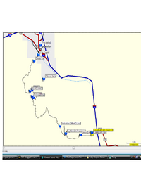
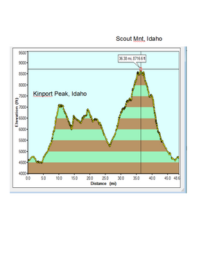
| − | + | Below is a description of a Motorcycle ride starting at the City Creek trail head in Pocatello and exiting at the "Good Enough" Campground at the Lava/Mcnammon exit. The trail is almost 50 Miles long. | |
| − | [[File:Map_Kinport-Scout_GoodENuf_7-11-10.png]] | + | [[File:Map_Kinport-Scout_GoodENuf_7-11-10.png | 200 px]][[File:Profile_Kinport-Scout_GoodENuf_7-11-10.png | 300 px]] |
| − | GPS_Kinport-Scout_GoodENuf_7-11-10.gpx | + | WARNING: The trail down to Good Enough Campground is hazardous, single track, loose rock. I am not sure if I could ride up it. |
| + | |||
| + | [[File:GPS_Kinport-Scout_GoodENuf_7-11-10.gpx.txt]] | ||
| + | |||
| + | |||
| + | |||
| + | |||
| + | [[TF_Motrocycle_Tails]] | ||
Latest revision as of 01:03, 12 July 2010
Below is a description of a Motorcycle ride starting at the City Creek trail head in Pocatello and exiting at the "Good Enough" Campground at the Lava/Mcnammon exit. The trail is almost 50 Miles long.
WARNING: The trail down to Good Enough Campground is hazardous, single track, loose rock. I am not sure if I could ride up it.
File:GPS Kinport-Scout GoodENuf 7-11-10.gpx.txt

