Difference between revisions of "TF MiddleForkSalmonID"
Jump to navigation
Jump to search
(Created page with '= Maps= GPS map Media:MiddleForkRivr_ID_2008.gpx.txt Media:MiddleForkRivr_ID_2012.gpx.txt PDF file Media:IDMiddleForkRiverMap_2012.pdf =Info= River measurement…') |
(→Maps) |
||
| Line 1: | Line 1: | ||
= Maps= | = Maps= | ||
| + | |||
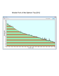
| + | [[File:MiddleForkSalmonProfile.png | 200 px]] | ||
GPS map | GPS map | ||
Revision as of 03:32, 11 July 2012
Maps
GPS map
Media:MiddleForkRivr_ID_2008.gpx.txt
Media:MiddleForkRivr_ID_2012.gpx.txt
PDF file
Media:IDMiddleForkRiverMap_2012.pdf
Info
River measurement of river levels at 2 locations
http://www.canyonsinc.com/waterlevels.raft
Fly
Amenities
Flying B resort at mile marker 75 has supplies
http://www.flyingresortranches.com/
Ron Waters from Outdoor adventure cener
Past Trips
TF_MiddleForkSalmon_2012
