Difference between revisions of "TF FlyFishn"
| (32 intermediate revisions by the same user not shown) | |||
| Line 1: | Line 1: | ||
| + | Idaho stocking schedule | ||
| + | |||
| + | http://fishandgame.idaho.gov/public/fish/stocking/ | ||
| + | |||
Try the orange and yellow | Try the orange and yellow | ||
| Line 6: | Line 10: | ||
=Fly fishing spots= | =Fly fishing spots= | ||
| + | |||
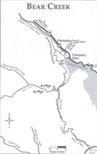
| + | == Bear Creek== | ||
| + | Drive accross the Palisades dam onto the dirt road from Highway 26 | ||
| + | Follow the signs to the Bear Creek trailhead | ||
| + | |||
| + | |||
| + | [[File:BearCreekID.png| 200 px]] | ||
| + | |||
==Beula Lake,Wy== | ==Beula Lake,Wy== | ||
[[BeulaLakeWY]] | [[BeulaLakeWY]] | ||
| + | |||
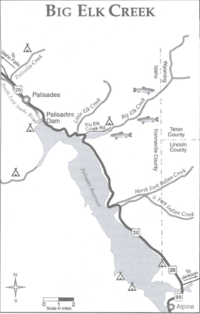
| + | == Big Elk Creek== | ||
| + | |||
| + | Take Highway 26 from Idaho Falls towards Palisade Resevoir | ||
| + | Look for Big Elk Creek campground 3 miles south east of the Dam | ||
| + | Turn northeast onto Big Elk Creek Road and park in the campground | ||
| + | Take a trail upstream | ||
| + | |||
| + | [[File:BigElkCreekMapID.png| 200 px]] | ||
| + | |||
| + | |||
| + | |||
| + | ==Bitch creek== | ||
| + | |||
| + | Turn east off of 32 on Jackpine Rd at GP location 43:55:31N,111:10:44W | ||
| + | Turn North onto Reece Rd at 43:55:31N, 111:08:59 W | ||
| + | Turn East onto 1400 N at 43:55:44N,111:08:59 W | ||
| + | road banks north ont 1425N at 43:55:44N,111:08:23W | ||
| + | becomes a rough dirt road at 43:56:23 N, 111:08:23 W (keep going straight there are two roads off the the east) | ||
| + | |||
| + | Covered Bridge | ||
| + | |||
| + | |||
| + | Turn east off of 32 on Jackpine Rd at GP location 43:55:31N,111:10:44W | ||
| + | Turn North onto Reece Rd at 43:55:31N, 111:08:59 W | ||
| + | continue straight until a very rough dirt road appears at 43:56:08N,111:08:50 W that will cut over to a better dirt road | ||
| + | |||
| + | ==Crow Creek== | ||
| + | |||
| + | Take highway 89 from Montpelier towards Geneva and into Wyomng | ||
| + | Go left on Highway 89/61 and drive north several miles to the Wyoming Highway 236 Intersection | ||
| + | (if you reach Afton you have gone too far) | ||
| + | Turn west and follow Highway 236 to Fairview | ||
| + | Turn south on Crow Creek road and follow the stream back into Idaho | ||
| + | |||
| + | Try hoppers, cricket, and ants to bring big brown and cutts up | ||
| + | |||
| + | |||
| + | [[File:CrowCreekID.pdf]] | ||
| + | |||
| + | == Cub River== | ||
| + | |||
| + | Drive south on interstate 15 to US highway 91 | ||
| + | Drive South on 91 through Virginia and Preston. | ||
| + | turn east on Cub River Road after passing the little berg of Whitney | ||
| + | Follow Cub River Road past the village of Mapleton and into Cache National Forest | ||
| + | The road runs parallel to the river and you can start fishing as soon as you enter the National Forest | ||
| + | |||
| + | If you want to fish at Willow Flat, just follow stay on Cub river road (FR 406) and look for the sign | ||
| + | You can keep going until you reach Birch Creek Road (FR 407) which will take you to Highway 36 and back to Preston | ||
| + | |||
| + | |||
| + | [[File:CubRiverID.pdf]] | ||
| + | |||
| + | ==East Fork of Rock Creek== | ||
| + | |||
| + | Fish where the water slows and as a result the pools are deep | ||
| + | |||
| + | Take interstate 86 west from pocatello to the junction with Idaho highway 37. | ||
| + | |||
| + | Drive south on 37 for 11 miles to the town of Rockland | ||
| + | |||
| + | Take a left at Center street in Rockland which becomes 4300 South after leaving town toward the east | ||
| + | |||
| + | Center will take a 90 degree turn to the north | ||
| + | |||
| + | less than a mile after the hard left north you will turn right onto East Fork road | ||
| + | |||
| + | public access is on the right after a short drive up the canyon | ||
| + | |||
| + | |||
| + | watch out for rattle snakes | ||
| + | |||
| + | try dry flies here | ||
| + | |||
| + | in the afternoon try chernobyls | ||
| + | |||
| + | Yellow Humpy worked in first week of October 2013 around the first camp site, float it under tree overhangs and near bends with deep holes | ||
| + | |||
| + | [[File:EastForkRockCreekID.pdf]] | ||
| + | |||
| + | |||
| + | ==Eightmile Creek== | ||
| + | |||
| + | From downtown Soda Springs you turn SOuth on Bailey Creek Road (Forest Road 197) | ||
| + | Turn left after several miles onto Nounan Road | ||
| + | turn right after about 1 mile when Nounan Road intersects Eightmile road (Forest Road 425), this will take you into Cahe National Forest | ||
| + | Eightmile creek will appear first on your left | ||
| + | cross over eightmile creek and start fishing upstream of the bridge | ||
| + | |||
| + | |||
| + | try to fish the beaver ponds | ||
| + | |||
| + | The farther up eightmile road you go the bigger the fish | ||
| + | |||
| + | Attractors like te #14 Royal Coachman work well | ||
| + | |||
| + | small prince nymph works well | ||
| + | |||
| + | |||
| + | big adams dry fly at dusk on the beaver ponds | ||
| + | |||
| + | 10" trout are common | ||
| + | |||
| + | |||
| + | [[File:EightMileCrkID.pdf | 200 px]] | ||
| + | |||
| + | == Georgetown creek == | ||
| + | |||
| + | take US 30 east from Soda springs about 15 miles to Georgetown | ||
| + | |||
| + | take a left on Creamery Lane in Georgetown and drive to Georgetown Canyon | ||
| + | |||
| + | fish the canyon in stretches of water that look good | ||
| + | |||
| + | no known for big trout mostly brookies | ||
| + | |||
| + | try Royal Coachman for brookies | ||
| + | |||
| + | rainbows and cuts go for weighted nymphs | ||
| + | |||
| + | wooly buggers or leech imitaters in the big pools | ||
| + | |||
| + | |||
| + | [[File:GeorgeTownCreekID.pdf]] | ||
| + | |||
| + | |||
| + | ==Henry's Lake Outlet== | ||
| + | |||
| + | |||
| + | [[TF_HenryLakeOutlet]] | ||
==Hidden Lake, MT== | ==Hidden Lake, MT== | ||
| Line 16: | Line 159: | ||
[[TF_HiddenLakeMT]] | [[TF_HiddenLakeMT]] | ||
| − | == | + | ==Little Lost River== |
| − | + | Drive west on US Highway 26 from Blackfoot | |
| − | + | Take a sharp right onto Highway 33/22 before you get to Arco | |
| + | Turn North onto the Little Lost River after driving 10 miles to Howe | ||
| + | Take the right fork (Sawmill Canyon Road) after driving 30 miles on the dirt road | ||
| + | Start fishing when you are in the canyon away from the private ranches | ||
| Line 30: | Line 176: | ||
[[TF_MiddleForkRivrID]] | [[TF_MiddleForkRivrID]] | ||
| − | == | + | ==Montpelier Creek== |
| + | |||
| + | Take US highway 89 east from Montpelier towards Geneva. | ||
| + | |||
| + | Stream is on the right side of the road as you drive up Montpelier canyon | ||
| + | You can access the stream after you enter National Forest lands | ||
| + | Cross the stream near Crow Creek road and look for a dirt road on the east side of the stream to park on | ||
| + | |||
| + | |||
| + | try stripping a wooly bugger into the current near dusk | ||
| + | |||
| + | Chernobyl ant s can be effective too | ||
| + | |||
| + | hopper and ant flies in the middle of the day | ||
| + | |||
| + | 17" rainbows are common | ||
| + | |||
| + | a few big brown trout | ||
| + | |||
| + | [[File:MontpelierCreekID.pdf]] | ||
| + | |||
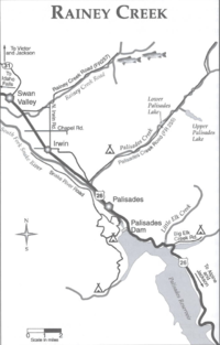
| + | ==Rainey Creek== | ||
| + | Drive on Highway 26 from Idaho Falls toward Swan Valley | ||
| + | Turn left on Rainey Creek Road which is just past the Swan Valley Post office & the square ice cream cone store | ||
| + | Park at the trail head past the primitive campground | ||
| + | |||
| + | [[File:RaineyCreekMapID.png| 200 px]] | ||
| + | |||
| + | ==Snake River, ID== | ||
| + | |||
| + | http://waterdata.usgs.gov/usa/nwis/uv?site_no=13077000 | ||
| + | |||
| + | [[TF_SnakeRivrID]] | ||
| + | |||
| + | ==South Fork River, ID== | ||
| + | |||
| + | [[TF_SouthForkRivrID]] | ||
| + | |||
| + | ==Stump Creek== | ||
| + | |||
| + | From Montpelier, drive east on 89 to Afton Wyoming | ||
| + | Drive west on Auburn Fish Hatchery road that is about 4 miles North of Afton | ||
| + | The road forks ,take the north road which is known as Stump Creek Road | ||
| + | A guard station appears after a couple of miles | ||
| + | Take a left on the road near the guard station | ||
| + | cross the bridge and find a spot to park | ||
| + | |||
| + | Go for big brown trout in the Fall that are going up stump creek to spawn | ||
| + | |||
| + | [[File:StumpCreekID.pdf]] | ||
| + | |||
| + | |||
| + | ==Teton River== | ||
| − | + | Between Victor and Driggs | |
| − | + | Bates Road Bridge: 43:41:47N, 111:09:54W | |
| − | + | Buxton Rd Bridge: 43:43:24M,111:11:16W (turn West on W. Little Ave) | |
| − | + | W 4000N Rd: 43:46:53N,111:12:34W (has a boat ramp, run west off of Hi 33 at 43:46:52N,111:06:38W) | |
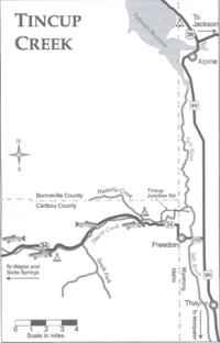
| + | ==Tincup Creek== | ||
| + | Go North on Highway 34 from Soda Springs | ||
| + | Highway 34 crosses Tincup creek after 20 miles or so | ||
| + | A dirt US Forest service road can take you upstream or you can go to Lone Pine Campground | ||
| − | + | [[File:TincupCreekID.png| 200 px]] | |
==Topance Creek== | ==Topance Creek== | ||
| Line 52: | Line 254: | ||
Float a cadis simulation dry fly near the banks. | Float a cadis simulation dry fly near the banks. | ||
| − | |||
| − | + | try yellow humpies | |
| + | |||
| + | grasshopper patterns late in the year | ||
| + | |||
| + | |||
| + | [[File:ToponceCreekID.pdf]] | ||
| + | |||
| + | |||
| + | |||
| + | |||
| + | |||
| + | == wild horse creek== | ||
| + | |||
| + | Go to Mackay (Highway 93), past Mackay reservoir , and turn left onto trail creek road at GPS coordinates 44 edges 4 minutes N and 113 degrees and 5 minutes West. | ||
| + | |||
| + | Turn left on wild horse creek road at GPS coordinates 43 degrees 55 minutes and 25 seconds North by 114 degrees 7 minutes and 17 seconds West. | ||
| + | |||
| + | |||
| + | The road will follow the creek and not cross it. | ||
| + | |||
| + | |||
| + | [[File:TrailCreekID.png| 200 px]][[File:RockCreekID.png| 200 px]][[File:PalisadesCreekMapID.png| 200 px]][[File:RobinsonCreekMapID.png| 200 px]] | ||
| + | |||
| + | |||
| + | [[File:McCoyCreekID.pdf]] | ||
Latest revision as of 19:57, 2 September 2014
Idaho stocking schedule
http://fishandgame.idaho.gov/public/fish/stocking/
Try the orange and yellow
http://www.discountflies.com/mm5/merchant.mvc?
Fly fishing spots
Bear Creek
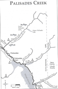
Drive accross the Palisades dam onto the dirt road from Highway 26 Follow the signs to the Bear Creek trailhead
Beula Lake,Wy
Big Elk Creek
Take Highway 26 from Idaho Falls towards Palisade Resevoir Look for Big Elk Creek campground 3 miles south east of the Dam Turn northeast onto Big Elk Creek Road and park in the campground Take a trail upstream
Bitch creek
Turn east off of 32 on Jackpine Rd at GP location 43:55:31N,111:10:44W Turn North onto Reece Rd at 43:55:31N, 111:08:59 W Turn East onto 1400 N at 43:55:44N,111:08:59 W road banks north ont 1425N at 43:55:44N,111:08:23W becomes a rough dirt road at 43:56:23 N, 111:08:23 W (keep going straight there are two roads off the the east)
Covered Bridge
Turn east off of 32 on Jackpine Rd at GP location 43:55:31N,111:10:44W
Turn North onto Reece Rd at 43:55:31N, 111:08:59 W
continue straight until a very rough dirt road appears at 43:56:08N,111:08:50 W that will cut over to a better dirt road
Crow Creek
Take highway 89 from Montpelier towards Geneva and into Wyomng Go left on Highway 89/61 and drive north several miles to the Wyoming Highway 236 Intersection (if you reach Afton you have gone too far) Turn west and follow Highway 236 to Fairview Turn south on Crow Creek road and follow the stream back into Idaho
Try hoppers, cricket, and ants to bring big brown and cutts up
Cub River
Drive south on interstate 15 to US highway 91 Drive South on 91 through Virginia and Preston. turn east on Cub River Road after passing the little berg of Whitney Follow Cub River Road past the village of Mapleton and into Cache National Forest The road runs parallel to the river and you can start fishing as soon as you enter the National Forest
If you want to fish at Willow Flat, just follow stay on Cub river road (FR 406) and look for the sign You can keep going until you reach Birch Creek Road (FR 407) which will take you to Highway 36 and back to Preston
East Fork of Rock Creek
Fish where the water slows and as a result the pools are deep
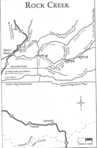
Take interstate 86 west from pocatello to the junction with Idaho highway 37.
Drive south on 37 for 11 miles to the town of Rockland
Take a left at Center street in Rockland which becomes 4300 South after leaving town toward the east
Center will take a 90 degree turn to the north
less than a mile after the hard left north you will turn right onto East Fork road
public access is on the right after a short drive up the canyon
watch out for rattle snakes
try dry flies here
in the afternoon try chernobyls
Yellow Humpy worked in first week of October 2013 around the first camp site, float it under tree overhangs and near bends with deep holes
Eightmile Creek
From downtown Soda Springs you turn SOuth on Bailey Creek Road (Forest Road 197) Turn left after several miles onto Nounan Road turn right after about 1 mile when Nounan Road intersects Eightmile road (Forest Road 425), this will take you into Cahe National Forest Eightmile creek will appear first on your left cross over eightmile creek and start fishing upstream of the bridge
try to fish the beaver ponds
The farther up eightmile road you go the bigger the fish
Attractors like te #14 Royal Coachman work well
small prince nymph works well
big adams dry fly at dusk on the beaver ponds
10" trout are common
Georgetown creek
take US 30 east from Soda springs about 15 miles to Georgetown
take a left on Creamery Lane in Georgetown and drive to Georgetown Canyon
fish the canyon in stretches of water that look good
no known for big trout mostly brookies
try Royal Coachman for brookies
rainbows and cuts go for weighted nymphs
wooly buggers or leech imitaters in the big pools
Henry's Lake Outlet
Hidden Lake, MT
Little Lost River
Drive west on US Highway 26 from Blackfoot Take a sharp right onto Highway 33/22 before you get to Arco Turn North onto the Little Lost River after driving 10 miles to Howe Take the right fork (Sawmill Canyon Road) after driving 30 miles on the dirt road Start fishing when you are in the canyon away from the private ranches
Middle Fork of the Salmon, ID
Middle Fork River, ID
Montpelier Creek
Take US highway 89 east from Montpelier towards Geneva.
Stream is on the right side of the road as you drive up Montpelier canyon You can access the stream after you enter National Forest lands Cross the stream near Crow Creek road and look for a dirt road on the east side of the stream to park on
try stripping a wooly bugger into the current near dusk
Chernobyl ant s can be effective too
hopper and ant flies in the middle of the day
17" rainbows are common
a few big brown trout
Rainey Creek
Drive on Highway 26 from Idaho Falls toward Swan Valley Turn left on Rainey Creek Road which is just past the Swan Valley Post office & the square ice cream cone store Park at the trail head past the primitive campground
Snake River, ID
http://waterdata.usgs.gov/usa/nwis/uv?site_no=13077000
South Fork River, ID
Stump Creek
From Montpelier, drive east on 89 to Afton Wyoming Drive west on Auburn Fish Hatchery road that is about 4 miles North of Afton The road forks ,take the north road which is known as Stump Creek Road A guard station appears after a couple of miles Take a left on the road near the guard station cross the bridge and find a spot to park
Go for big brown trout in the Fall that are going up stump creek to spawn
Teton River
Between Victor and Driggs
Bates Road Bridge: 43:41:47N, 111:09:54W
Buxton Rd Bridge: 43:43:24M,111:11:16W (turn West on W. Little Ave)
W 4000N Rd: 43:46:53N,111:12:34W (has a boat ramp, run west off of Hi 33 at 43:46:52N,111:06:38W)
Tincup Creek
Go North on Highway 34 from Soda Springs Highway 34 crosses Tincup creek after 20 miles or so A dirt US Forest service road can take you upstream or you can go to Lone Pine Campground
Topance Creek
Backside of Pebble creek.
went downstream from the bridge.
Float a cadis simulation dry fly near the banks.
try yellow humpies
grasshopper patterns late in the year
wild horse creek
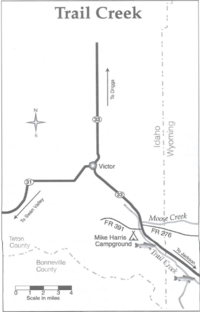
Go to Mackay (Highway 93), past Mackay reservoir , and turn left onto trail creek road at GPS coordinates 44 edges 4 minutes N and 113 degrees and 5 minutes West.
Turn left on wild horse creek road at GPS coordinates 43 degrees 55 minutes and 25 seconds North by 114 degrees 7 minutes and 17 seconds West.
The road will follow the creek and not cross it.
